Hurricane Ian Eyewall Moving Ashore; Catastrophic Florida Strike Begins
Disaster Alert
September 28, 2022
Source: The Weather Channel
Hurricane Ian is nearing landfall as one of southwest Florida’s most intense hurricanes on record, expected to produce catastrophic storm surge, destructive winds and flooding rainfall.
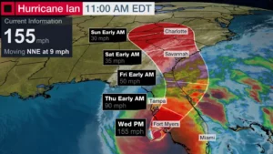
Ian is a Category 4 hurricane packing maximum sustained winds of 155 mph.
Some coastal gauges are now reporting water rises, the beginning of Ian’s storm surge, including in Naples, Florida, where over 4 feet of storm surge inundation has been measured, more than any other storm at that gauge location in at least 50 years.
Meanwhile, winds blowing offshore have produced a blowout tide in Tampa Bay Wednesday morning.
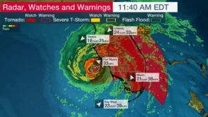
Bands of heavy rain containing strong wind gusts are lashing parts of the Florida Peninsula and the Florida Keys right now.
Winds have recently gusted up to 62 mph in Ft. Myers and Naples. Gusts over 40 mph have been clocked on the Atlantic side in Melbourne, Florida. Street flooding was reported in Stuart, about 100 miles north of Miami.
Winds have gusted from 40 to 80 mph in Key West since Tuesday, where Ian also produced the third highest storm surge in over 100 years.
A tornado watch is in effect for central and southern Florida until 5 p.m. EDT.
Current Watches, Warnings
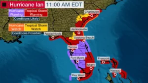
Hurricane warnings (shaded in purple in the map below) now stretch across the Florida Peninsula from southwest to central to Florida’s Space Coast, including including Tampa-St. Petersburg, Fort Myers, Orlando and Daytona Beach. This means hurricane conditions are expected.
A storm surge warning is also in effect along much of Florida’s west coast, from the mouth of the Suwanee River to the Lower Keys, including Tampa Bay, and also on the Atlantic side from the Flagler-Volusia County line in northeast Florida to the entire Georgia coast to Charleston County, South Carolina, including Florida’s St. Johns River. This means life-threatening flooding from rising water moving inland from the coastline is expected.
A hurricane watch extends from northeast Florida’s coast to Charleston County, South Carolina, where hurricane conditions are possible.
Tropical storm warnings extend from the Florida Keys northward to southeast Florida, the northwestern Bahamas, the Florida Big Bend and from northeastern Florida to the border of North Carolina and South Carolina, as you can see in the map below.
Forecast Path, Intensity
Landfall of Ian’s center should occur this afternoon between Sarasota and Fort Myers.
Ian should remain at least Category 4, but could make an extremely rare Category 5 landfall this afternoon. Regardless, Ian will be a life-threatening, catastrophic landfall, one of southwest Florida’s strongest hurricanes on record.
After that, Ian will move over the central Florida Peninsula and eventually weaken to a tropical storm. Ian could then emerge briefly over the Atlantic waters before turning back toward the Georgia or South Carolina coasts as a tropical storm or low-end hurricane Friday and Friday night.
Forecast Impacts
Storm Surge
Ian will produce catastrophic storm surge along parts of the southwest Florida coast.
The map below shows possible peak storm surge inundation, if that happens at the time of high tide, according to the National Hurricane Center.
The peak surge, possibly up to 18 feet, will occur near and south of where the center makes landfall in southwest Florida on Wednesday. That could be between Englewood and Bonita Beach, including Charlotte Harbor.
NHC senior meteorologist Eric Blake noted Wednesday morning nobody alive has witnessed storm surge as high as forecast for Ian in southwest Florida. This could, in fact, be a record storm surge for southwest Florida, according to data from the National Weather Service.
Storm surge is also expected on the Atlantic side of northeast Florida and into coastal Georgia and South Carolina beginning late Wednesday or Thursday. Given the wind direction out of the northeast as this may occur, the St. Johns River in northeast Florida may back up and flood.
Due to persistent onshore winds even as Ian’s center moves farther away, coastal flooding may last for some time beyond the peak storm surge into Friday or even early Saturday in western Florida and along the areas shown below along the Atlantic Southeast coast.
Wind Threat
Wind damage from Ian will be catastrophic near where its eyewall tracks inland into the southwest Florida coast. That will include the stretch of coastline from Sarasota to Port Charlotte and Fort Myers.
Power outages and downed trees are likely in areas under hurricane and tropical storm warnings. Those outages could last for days or weeks in locations that see the highest winds.
Structural damage is possible, with the greatest threat near where the core of the hurricane’s center tracks in western and southwestern Florida.
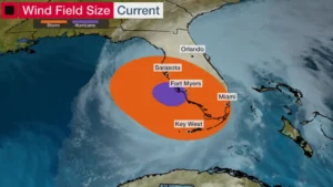
The map below shows where sustained tropical storm and hurricane force winds are ongoing as of the latest National Hurricane Center advisory.
Rainfall
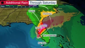
Heavy rainfall is another dangerous threat from the Florida Peninsula into portions of the Southeast through the weekend.
Here’s the latest rainfall forecast from the National Hurricane Center.
-Florida Keys and South Florida: 6 to 8 inches, with locally up to 12 inches.
-Central and Northeast Florida: 12 to 18 inches, with locally up to 24 inches.
-Eastern Georgia and coastal South Carolina: 4 to 8 inches, with locally up to 12 inches.
This heavy rain is likely to trigger dangerous, potentially catastrophic flash flooding in parts of Florida, especially in urban areas, along with river flooding that is likely to last for days after Ian is over.
Additional locally heavy rain and flash flooding is possible this weekend as Ian or its remnant pivots into the southern Appalachians and Mid-Atlantic states, particularly in mountainous terrain.
Isolated tornadoes are also a threat across much of the Florida Peninsula on Wednesday, in northeast Florida Thursday and the coastal Carolinas Friday.
Check back with us at weather.com for the very latest on this developing situation.
For full report, please click the source link above.


