Idalia Live Briefing: Florida Braces for Major Hurricane as Storm Strengthens
Disaster Alert
August 28, 2023
Source: MSN/The Washington Post
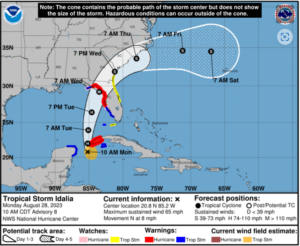
Tropical Storm Idalia (pronounced “ee-DAL-ya”) strengthened quickly Sunday night and is forecast to strike Florida’s Gulf Coast as a major hurricane Wednesday after drawing strength from the record-warm Gulf of Mexico. The storm is projected to come ashore between Tampa Bay and the eastern Florida Panhandle, unleashing “a life-threatening storm surge and hurricane-force winds,” according to the National Hurricane Center. The greatest risk is in the Big Bend region of Florida, particularly overnight Tuesday into Wednesday morning.
Hurricane and storm surge warnings have been issued for the zone that includes Tampa, Tampa Bay, Clearwater, Cedar Key and the coastal zone south of Tallahassee.
Gov. Ron DeSantis (R) emphasized that many of those living in the storm’s path will lose electricity for an extended period, which is why the state will position utility workers on Monday to respond.
“The risk continues to increase for a life-threatening storm surge and hurricane-force winds along portions of the west coast of Florida and the Florida Panhandle beginning as early as Tuesday,” the Hurricane Center wrote.
Track the storm path of Idalia
Even after Idalia makes landfall and then pulls away from Florida into Thursday, its moisture could interact with a cold front and drop up to half a foot of rain across the Southeast. Eastern Georgia and the Carolinas could face flooding rains, as well as the risk of a few tornadoes.
Key developments
Idalia is picking up speed and is on the move toward the Gulf of Mexico. As of 11 a.m. Eastern time, the center of Tropical Storm Idalia was located 80 miles south-southwest of the western tip of Cuba. After hardly budging Sunday, it was moving due north at 8 mph.
The storm is strengthening. Maximum sustained winds in the core of the storm increased to 65 mph Monday morning, and it is likely that Idalia will become a hurricane — meaning it has winds of at least 74 mph — by evening. The Hurricane Center wrote the storm’s satellite presentation had “improved” with tall thunderstorms surrounding the storm center.
Hurricane warnings stretch from just north of Sarasota into the eastern Florida Panhandle, as far west as the coastal zone south of Tallahassee. A warning is also in effect for the western Cuban province of Pinar del Río. Tropical storm warnings affect the zone from around Sarasota to just south of Naples and a sliver of the Panhandle coast from southwest of Tallahassee to southeast of Panama City. A hurricane watch is in effect for the area around Sarasota.
Storm surge warnings stretch from just north of Port Charlotte through Sarasota, Tampa Bay and Cedar Key into the coastal zone south of Tallahassee.
The Hurricane Center is now forecasting that the storm will make landfall as a Category 3 hurricane with peak winds of 115 mph; any storm rated Category 3 or higher is considered a “major” hurricane.
President Biden spoke to Gov. DeSantis on Monday morning, noting that he had approved an emergency declaration for the state as the storm approaches, according to a White House pool report.
Tampa International Airport will close beginning at 12:01 a.m. Tuesday, and will remain so until it can “assess any damages later in the week.”
Forecasters see two key ingredients that will help the storm gain strength:
Water temperatures in the eastern Gulf of Mexico are in the upper 80s to near 90 degrees, several degrees above average and in record territory, which will fuel intensification.
An approaching dip in the jet stream over the eastern United States will effectively evacuate “exhaust” air at high altitudes away from Idalia, allowing it to ingest more warm, humid air from below and continue to strengthen — perhaps right up until the point of landfall.
“The bottom line is that rapid intensification is becoming increasingly likely before landfall” on Wednesday morning, the Hurricane Center wrote. Computer modeling indicates that the odds of rapid intensification are between 5 and 10 times the average.
The storm surge — or rise in seawater above normally dry land at the coast — could reach 11 feet in the hardest-hit areas. Florida’s Big Bend area could see the biggest surge and is particularly vulnerable because of the adjacent gently sloping sea floor, which makes it easy for water to pile up along the coast and for the surge to penetrate miles inland. The current forecast calls for a surge of 4 to 7 feet around Tampa if the peak surge coincides with high tide, which would be its highest on record.
***Note: This event has not yet been declared a FEMA disaster. We will update you as more information becomes available.***
To order an inspection, please log-in to your SafeView Access account.
To read the full articles, please click the source links above.


